On The Wing – Spring 2024
Uncovering the hidden realities of wild places
Recently, as I sat on a plane cruising at 30,000 feet above the Earth, I couldn’t help but think about the total solar eclipse people were witnessing below. Although I missed viewing it firsthand, the remarkable images I saw afterward reminded me of nature’s constant ability to amaze us.
Just as with the solar eclipse, there are hidden marvels all around us – things we may not always see but which hold immense wonder and purpose. In this edition of On the Wing, we highlight how LightHawk is using the aerial perspective to uncover the hidden realities of our wild places and provide an unmatched view of their beauty and significance.
Collaborating with partners at the Wildfire Resilience Funders network, we’re working to protect landscapes and enhance wildfire resilience to climate-related risks in the western regions. Meanwhile, on the eastern side of the country, The Trustees of Reservations are overseeing 393 Conservation Restrictions, spanning over 20,000 acres. LightHawk’s flights are providing crucial support to their small stewardship team in monitoring these extensive lands.
Together, we are revealing the delicate balance of ecosystems and the close connections between humans, nature, and the climate. By doing so, we highlight how working with nature benefits us all and inspire people to take action.
Thank you for soaring with us on this amazing journey, especially on Earth Day, as we strive to care for and protect our natural world.
Warm regards,
Joanna Weitzel
Director of Advancement
UPCOMING FLIGHTS
- Donor flight in Mexico with partner Restauramos el Colorado.
- Photo/video flight in Alaska with partner Native Village of Dot Lake
- A flight to document coastal conditions in Oregon with partner Oregon Shores Conservation Coalition
- Aerial shorebird survey in the Colorado River Delta with partner National Audubon Society
- Video flight over the Colorado River for documentary with partner Finch No Worries
- Flight to survey old corn fields to bring back dry-land farming methods in Arizona with partner To Nizhoni Ani
- Video flight over the Butte Creek watershed in California with partner Friends of Butte Creek
- Aerial imagery camera equipment test flight with partner Samish Indian Nation
- Flight to observe critical areas for grizzly bear survival and movement in Montana with Partner Yellowstone to Yukon
- Donor flight in California with partner Greenbelt Alliance
- Multiple masked bobwhite quail transport flights with partner George Miksch Sutton Avian Research Center
- Aerial survey of black-backed woodpeckers in the Oregon Cascades region with partner Oregon State University
- Multiple Mexican wolf cross-foster flights with partner Mexican Wolf Species Survival Plan
- Photo flight to document conditions of Paulina Lake/Dam in New Jersey with partner The Nature Conservancy
- Multiple aerial survey flights along sections of Cape Cod, MA with partner Manomet Center for Conservation Sciences
- Multiple algal bloom monitoring in Florida with partner Rivers Coalition
- Test flight for multispectral imaging system in New Hampshire with partner University of New Hampshire
- Flight to provide overview of ongoing wetland restoration work across the Florida Everglades with partner Everglades Foundation
- Whooping crane nesting survey flight in Wisconsin with partner International Crane Foundation
- Multiple King Tide videography flights across the East Coast
- Educational flight for stakeholders of the largest pine barrens in New England with partner Massachusetts Coastal Pine Barrens Partnership
Protecting wild places from future development

The 47,000 acres of lands managed by The Trustees of Reservations (The Trustees) holds 393 Conservation Restrictions – comprising more than 20,000 acres – which connect and protect 54 Trustees reservations across Massachusetts. Conservation restrictions (also known as conservation easements) are one of several methods land trusts use to protect habitat across the nation. With conservation restrictions in place, each of the 393 locations requires the stewardship staff monitor the lands each year to ensure the conservation values are upheld. This is a daunting task for a small stewardship team.
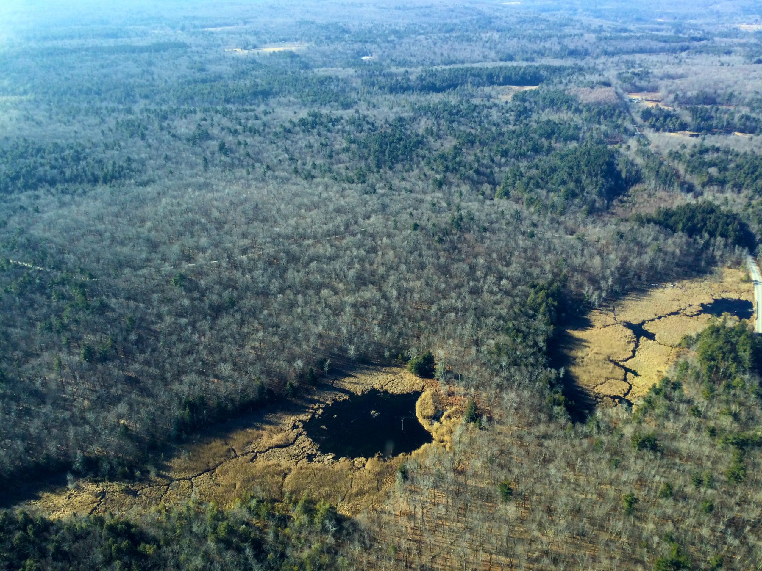
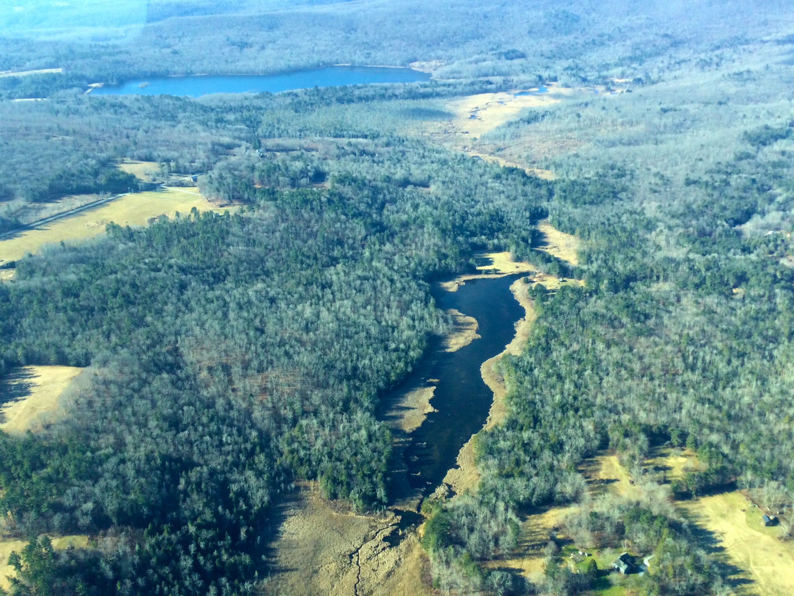
In late 2023, LightHawk collaborated with the Trustees to assess the existing conditions of several large acreages, perpetual Conservation Restrictions (CRs) held by The Trustees of Reservations in southern Berkshire County and Salisbury, Connecticut to fulfill their yearly monitoring requirements. These large acreage properties (500-875 acres) are located in heavily forested lands, on very steep terrain, with many areas that cannot easily or safely be accessed on foot.
“Our team aimed to capture clear photos of our conservation restrictions while also exploring the most effective ways to utilize aerial flyovers as a future monitoring tool. We use satellite imagery from a third-party resource so we were interested to see how the imagery compares to photos taken from an aerial flyover. There is no comparison! The crisp photos and perspective gained from this LightHawk flight was essential. I was able to gain a better understanding of the terrain and overall scale of some of our larger conservation restrictions. This flight provided an educational opportunity that we plan to share with landowners, coworkers, and other land trusts. We have large acreage properties that we can’t cover on foot every year. The flyover made it possible to view the whole property at once, as opposed to visiting a fraction of it every year.”


Sally Nasser from The Trustees of Reservations had this to say about the LightHawk flight, “This flight helped us wrap up our 2023 CR monitoring visits to numerous large acreage and hard to monitor ‘boots on the ground’ properties due to steep terrain as well as inaccessible areas due to beaver flooding and impenetrable regrowth on one property post timber harvest. In addition to using the photos we captured to complete our annual monitoring reports, we also flew over several properties owned in FEE by The Trustees of Reservations (TTOR) to capture photos that will help to guide our ecologists on future land management decisions. Sharing the aerial photos with our CR landowners as well as fellow TTOR coworkers outside of the Land Conservation Program is also proving to be a valuable engagement tool by helping to raise awareness of why land conservation matters, now more than ever! The valuable new perspective we gained would not have been possible without the generosity of LightHawk and their dedicated volunteer pilots.”
LightHawk volunteer pilot and Board President Steve Kent traveled from Warwick, New York to donate this flight to help the stewardship staff assess, photograph, and complete their annual monitor effort for these remote lands on time.
Be part of history with LightHawk’s 50-in-50 Challenge!
From June 15 to August 3, 2024, LightHawk is launching a groundbreaking mission: 50 Conservation Flights in 50 Days.
Over 50 days, we will conduct 50 conservation flights with partners, highlighting some of the most urgent conservation issues across the country.
We need your help to make this ambitious goal possible. Thanks to a generous $100,000 matching gift, your support will play a crucial role in leveraging this match, doubling the impact of your contribution!
Be part of history in the making by joining us in this ambitious and innovative nationwide conservation initiative – 50 Conservation flights in 50 days!
Visit https://Lighthawk.org/50-in-50/
Or scan the QR code on the left to be part of the first ever 50-In-50 Challenge!

CLIMATE CORNER
An aerial view of climate change

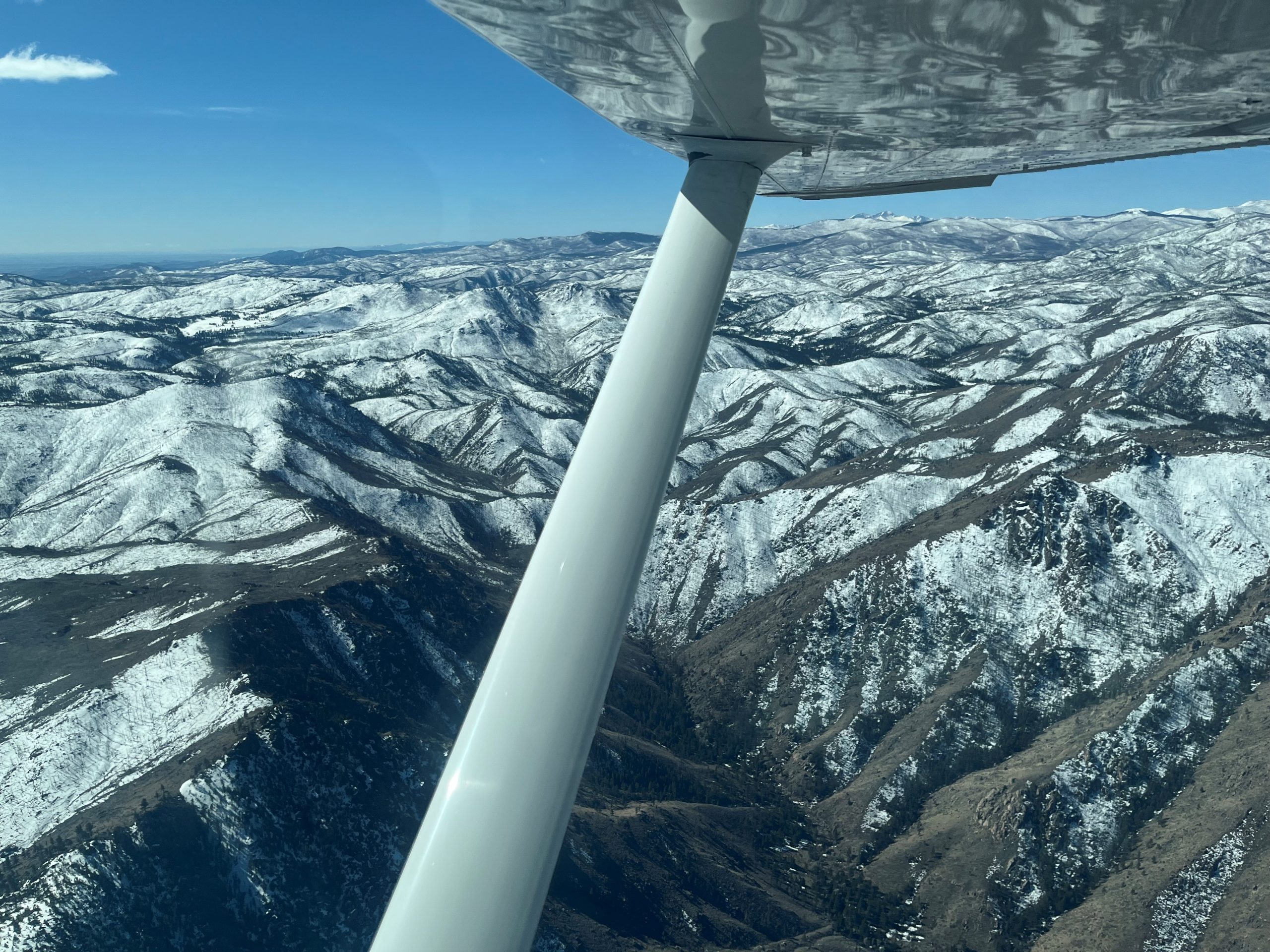
Sometimes LightHawk conservation efforts can get a little bit complicated. This April, it took three pilots and three planes to pull off a mission to assess the impacts of climate change on Colorado forests. For this effort, we partnered with the Wildfire Resilience Funders Network, the Climate Resilience Fund, and Coalitions and Collaboratives, Inc.
The Wildfire Resilience Funders network (WRF) is an affiliate group of more than 75 philanthropic and partner organizations that focus on addressing wildfire resilience issues in the western United States. The Climate Resilience Fund hosted the network as one of their programs focused on community and landscape resilience to climate-related risks and impacts. In April, WRF members traveled to Fort Collins, Colorado to learn about recent regional experiences with wildfire, and to explore opportunities for collaboration.
LightHawk and Coalitions and Collaboratives organized a flyover of two significant wildfire burn areas close to their meeting site, to provide learning opportunities about the Cameron Peak and High Park fires. Guides from knowledgeable organizations and agencies accompanied the members on the flight. To accommodate the many passengers, LightHawk pilots Warren Dean, Evan Anderman and Rick Turley provided their time, skills and airplanes.
PARTNER SPOTLIGHT
Greenbelt Alliance

Since 2021, LightHawk has joined forces with San Francisco’s Greenbelt Alliance, working together to further their mission of educating, advocating, and collaborating to enhance the resilience of the Bay Area’s lands and communities in the face of climate change.
With more than 3.3 million acres of natural lands protected from sprawl development, LightHawk has utilized our unique aerial resources to support the Greenbelt Alliance in illustrating the impact of sea-level rise on local communities, emphasizing the importance of preserving marshlands and promoting climate-smart growth. LightHawk’s donor flights have also provided a unique bird’s-eye view of Greenbelt Alliance’s Resilience Hotspots, contributing to a generous donation exceeding half a million dollars for their organization in 2023.
We look forward to continuing our collaboration with Greenbelt Alliance as we join forces to support their efforts in safeguarding wild lands within the region.
Lead the Charge: Become a Conservation Visionary
Ready to soar as a Conservation Visionary with LightHawk? Our mission: saving the Earth, one flight at a time! As a Visionary, your monthly support fuels our commitment to fly and safeguard wild landscapes, advance scientific research, and document environmental threats unlike any other. Even modest donations make a big impact, empowering collaboration and shaping policies that drive meaningful change for our planet. Join us now, and let’s take flight on a greener path!
